
MUST SEE IN THE U.P.
Porcupine Mountains - Waterfalls
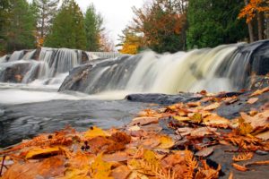
Hundreds of waterfalls grace the Porcupine Mountains and the surrounding area. You’ll find more than 90 waterfalls in the Porcupine Mountains Wilderness State Park alone! Each season of the year presents different aspects of these natural wonders. In the springtime, the streams and rivers are swollen with meltwater, providing an awe-inspiring spectacle of rushing water. During the summer, each waterfall becomes an idyllic garden scene amid the lush green forest landscape. Fall brings the visual backdrop of the changing leaves. And in the winter, the cold transforms the waterfalls into mesmerizing ice sculptures.
See map of some of the area’s best-known waterfalls.
See videos of these amazing waterfalls.
Seven Waterfalls You Must See.
Highlighted Waterfalls
- Agate Falls – Middle Branch of the Ontonagon River – Head east on M-28 from Bergland, six miles east of Bruce Crossing (map)
- Ajibikoka Falls – Sucker Creek – Located 4.5 miles northwest of Watersmeet off of Forest Rd 206
- Black River Harbor Falls – Black River – Head west on M-28 to US-2 through Bessemer
- Bonanza Falls – Big Iron River – Located 0.9 miles south of M-107 on M-64 South (map)
- Bond Falls – Middle Branch of the Ontonagon River – Take US-45 south from Bruce Crossing to Paulding (map)
- Cascade Falls – Cascade Creek – Take USFS 222 (which becomes 400) northeast from M-28 (map)
- Deer Creek Falls – Deer Creek – Seven miles northwest of Bergland
- Eighteen-mile Rapid Falls – South Branch of Ontonagon River – Located 5.5 miles south of Ewen
- Explorers Falls – Little Carp River – In Porcupine Mountains Wilderness State Park, three miles upstream from Lake Superior (map)
- Flannigan Rapids Falls – South Branch of Ontonagon River – Five miles north of Ewen
- Greenstone Falls – Little Carp River – Porcupine Mountains Wilderness State Park, one mile north of South Boundary Road (map)
- Irish Rapids and Grand Rapids Falls – Ontonagon River – Five miles northwest of Rockland
- Lepisto Falls – Presque Isle River – Just East of Hwy 519 near western border of Porcupine Mountains Wilderness State Park (map)
- Little Falls – Middle Branch of the Ontonagon River – Located 4.5 miles southwest of Paulding
- Little Trap Falls – Anderson Creek – Located 6.5 miles north of Bergland
- Little Union Gorge Falls – Little Union River – In Porcupine Mountains Wilderness State Park, 2.5 miles southwest of Silver City
- Meximine Falls – Tamarack River – Six miles east of Watersmeet on Forest Rd 208
- Nimikon Falls – Presque Isle River – Thirteen 13 miles west of Bergland (map)
- Nonesuch Falls – Iron River – In Porcupine Mountains Wilderness State Park, located 1.5 miles west of White Pine (map)
- Park at the North Country Hiking Trail parking lot and hike about 1.25 miles to the falls (map)
- Onion Falls – East Branch of the Ontonagon River – Seven miles northwest of Kenton (map)
- Pewabeck Falls – Little Iron River – Three miles north of White Pine (map)
- Presque Isle River waterfalls – Presque Isle River – Series of waterfalls: Iagoo, Nawadaha, Manido and Manabezho—Located at the westernmost edge of the Porcupine Mountains Wilderness State Park along Hwy 519 (map)
- Rapid River Falls – Rapid River – Five miles northwest of Bergland (map)
- Rock Bluff Falls – Bluff Creek – Ten miles north of Watersmeet (map)
- Sandstone Rapids Falls – Stranton Creek – Nine miles north of Ewen
- Shining Cloud Falls – Carp River – Porcupine Mountains Wilderness State Park, two miles upstream from Lake Superior (map)
- Sparrow Rapid Falls – East Branch of the Ontonagon River – Three miles northwest of Kenton
- Three Rapid Falls – Middle Branch of the Ontonagon River – Ten miles northwest of Agate
- Trap Falls – Carp River – In Porcupine Mountains Wilderness State Park, five miles southwest of Silver City (map)
- Trappers Falls – Little Carp River – In Porcupine Mountains Wilderness State Park, three miles upstream from Lake Superior (map)
- Traders Falls – Little Carp River – In Porcupine Mountains Wilderness State Park, one mile upstream from Lake Superior (map)
- Victoria Dam – West Branch of Ontonagon River – Four miles southwest of Rockland (map)
- Wolverine Falls – Middle Branch of the Ontonagon River – Eight miles west of Paulding (map)
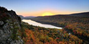
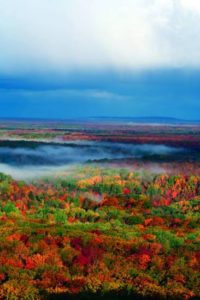
Fall Colors in the U.P.
Breathtaking vistas, country roads and walks on the lakeshore are some of the many ways you can enjoy the colors in the Western Upper Peninsula. Kermit Holt of the Chicago Tribune wrote of the fall colors: “Nowhere in North America, not even New England are the colors of autumn more vivid and memorable than in Michigan’s Western Upper Peninsula.”
Experience a fall vacation of reds, oranges, golds, and greens that tint the maple forests in the Lake Gogebic Area from mid-September to early October. Ninety percent of the area is forest covered, so your eyes will have plenty to take in.
The colors outlined by the mountains, bluffs, and lakes form postcards around every corner. There is nothing that can match one of our lakes or waterfalls wrapped in the brilliant colors of Autumn. Come see the burst of color for yourself or take a friend along for the company.
1. Bond Falls – Paulding, Michigan
Bond Falls is one of those “best kept secret” spots in the Upper Peninsula that you want to make sure you do not miss. This beautiful water fall is located on the middle branch of the Ontonagon River near Paulding. Although it does not get the “press” of more famous U.P. water falls, Bond Falls has a large following of admirers and had even been part of a calendar listing the most scenic natural places in the world!
2.Superior Falls – Extremely beautiful gorge. Access is moderately easy.
Directions: From Hwy US 2 in Ironwood. Go North on Lake Rd. This is approximately 25 mile drive. You will see a marker on the road that says Superior Falls. Turn north (right) on that gravel road. Continue down the small hill to the parking lot. Walk down the road to the River Mouth and Lake Superior. Then walk upstream 1/3 mile to Superior Falls. Superior Dam Falls is a little further upstream. If you have time, stop at Little Girls Point Park for a picnic. You will see this park on Lake Road on your way to the Falls.
3. Agate Falls – Western U.P.
Large beautiful waterfall that is visited by many people. Located just off of M-28 The short hiking trail is well-marked and easy to find.Directions: Go 6.5 miles East of Bruce Crossing on Hwy M-28. You will see a sign on the Hwy at the Bridge. Park in the parking area on the south. Follow the well marked trail under the bridge to the waterfall.
4. Black River Scenic Byway is a must and is featured in USA TODAY’s “Scenic fall road trips for your budget”
iv. Sandstone Falls – This waterfall meanders over rocks giving it a unique appearance. It is located on a beautiful spot on the Black River, with a well marked, short 1/4 mile walking trail.
v. Rainbow Falls – A Beautiful Waterfall that is extremely photogenic on the East part of the River. Enjoy the scenery on your 1/2 mile walk to the waterfall. Take is easy, there are many stairs.