
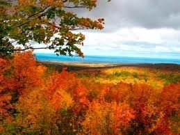
 The fall color in Michigan’s Western Peninsula offers some of the finest forest hues. Over 90 percent of the region are forest covered and in the fall, the colors explode. The colors are accented by the surroundings that carry them down root beer tinted water and float to soft forest floors.
Most of the colors are brilliant reds, radiant yellows and a deep pumpkin orange. The vast hardwood forests hold more colors than an artists palette. You’ll even spot russet oaks with hints of purple and brown. There’s no need to travel far and wide to view a bust of color, it’s all here, in Michigan’s Western U.P.
There are many great fall color tours in the Lake Gogebic are but one of the nicest is to start a tour at the top of Lake Gogebic. Lake Gogebic is the Upper Peninsula’s largest lake. 18 miles long and 3 miles wide, the driving distance around the lake is a little over 38 miles. Again take your time and enjoy the colors.
Head West on M28 when you leave AJ’s and take a left on M64 about 3 miles. As you head south you will see the Ontonagon County Park which is a nice place to stop and enjoy. Continue down the lake and you will go up a series of hills. As you go up the 3rd hill, you will see a hiking sign on the right and you may park on the left in front of the brown garage. You have arrived at Allegator Eye where you can climb to the highest point near Lake Gogebic, and you will be at the eye of the Alligator.

Picture taken on Alligator Eye Overlook on Lake Gogebic
Folklore has it that before the forests grew, when viewed from the lake; the area appeared to resemble the shape of an alligator. When you reach the eye you may be lucky enough to find Indian Artifacts which the area was known for. After you hike Allegator Eye, you can continue down M64 and you’ll see a sign for the East Shore road to your left. Follow that road and you’ll be at the bottom of the lake. As you come around the bottom of the lake you’ll see a small park like area where you can stop and check out the view. Then head back up the East Shore of Lake Gogebic. When you near the top of the lake you’ll see a road off to the left which takes you to the Bergland dam and that is also a nice vantage point and place to stop. When you reach the top of the lake you’ll come to M28 again. From there you can either head east to Agate Falls, Bond Falls and Kun De Kun, or you can head West and look for M64 Norther where you can head to the Porcupine Mountains.
The sprinkling of evergreens, staying true to their color year round help the woodland stars of autumn to shine through. Hikes along colored leaf lined paths and view our brilliant fall foliage.
Basswoods, ash, birch, aspen, sumac, elder, oaks and maple embrace the land. Stately branches of the white pine, the magnificent and too-uncommon evergreen, Michigan’s state tree, majestically tower over like a king watching over it’s forested kingdom. Back in the bogs, dark cone-shaped spruces stand posted amid the fiery hardwoods. It’s a quiet hush of Mother Nature at her finest.
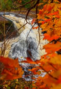
The waterfalls also provide a nice backdrop to the fall colors. Some of the more popular and easy to find waterfalls are along the National Scenic Byway on Black River Road heading towards Lake Superior. The hike through hemlock stands and groves of maple and birch is well worth it.
There’s a selection of five waterfalls to tour, Great Congolomerate, Potawatomi, Gorge, Sandstone and Rainbow Falls. The footpath to Great Conglomerate Falls, on the Black River, north of Big Powderhorn Ski area, past Copper Peak winds through an almost pure stand of sugar maple.
If you’re seeking the adventure of a picture perfect fall color journey,just head up to the Lake Gogebic area in Michigan’s Upper Peninsula.
Fall Color Tours
150 Mile Western U.P. Color Tour
Porcupine Mountains Fall Color Explosion
Tour Highlights: Cisco Chain of Lakes, Bond Falls, Porkies and Presque Isle falls
This tour takes you to some of the most spectacular scenery this country has to offer. You Start in Wakefield on Hwy 2 heading east. As you travel this road you are driving through the heart of the Ottawa Ntl Forest.
There are several side roads you can travel. Maps are available at the Forest Service offices. At the intersection of Hwy 2 & 45 turn north.
In Paulding you will see the signs for Bond Falls. This is a good spot for a stop. After Bond Falls you can continue on this road to Hwy M28 the second portion of this road is a good gravel road. Or return to 45 and continue north.
If you continue you will intersect M28 go west and stop at Agate Falls if you like. At the intersection of M28 & 45 go north to Ontonagon, a good stop for lunch and shopping. Here take M64 along the shore of Lake Superior to the West all the way to “Lake of The Clouds” on Hwy M-l07.
Next take South Boundary road south. Along the way stop at the Visitors Center. Summit Peak is a great lookout for colors. At the end of South Boundary Road is Cty Rd 519. Go north for 1 mile and get out of the car and walk to the waterfalls. There is a boardwalk along the river to the shore of Lake Superior.
Return to Wakefield on 519 to Hwy M28 & turn right and you will find yourself back where you began. This tour is a full day so take plenty of film.
Western U.P. Waterfall Color Tour
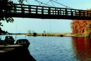
This is a simple trip, however the views are anything but simple. The Black River Scenic Byway is a protected road way by the Federal Government. It includes several waterfalls, Copper Peak ski flying hill and a walking suspension bridge over the river. This route while short is a good route to spend most of your time out of the car.
To begin you turn to the north off US-2 at the entrance to Big Powderhorn Mountain. The entrance is marked by the big skier. Follow the road to the main lodge of the ski resort. There the road turns to the right, follow it over the railroad tracks to a T intersection, here you turn left on to Black River Road. This will take you out to the waterfalls. Each of the waterfalls have paths leading to them. Potawatomi is barrier free (from the Gorge Parking Lot) with bath room facilities. Gorge and Rainbow have steps and observation decks, while Great Conglomerate and Sandstone falls have natural settings. At the harbor there is also a bathroom and picnic area. Black River Harbor also includes a campground, cabins and shopping. Enjoy this trip short in distance long on scenery.
50 Mile Fall Color Tour
Lake Superior Shoreline
Tour Highlights: Little Girls Point, Lake Superior, Gogebic County Forest, Superior Falls and Saxon Harbor
This tour takes in a little of everything our area has to offer. You begin in Ironwood at the intersection of US and Lake Rd, the Holiday Gas Station is there. Take Lake road north. You will travel about 15 miles. At this point you will enter the Gogebic County forest and begin to go downhill. Half way down this hill is a spring with good drinking water.
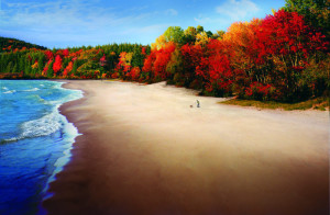
As you continue on Lake Rd (513) you will come to Little Girls Point. This park is a great place to get out and stretch your legs. Take some time to walk the beach and listen to the waves of the Big Lake. This stretch of land is rich in history. It was the site of Indian villages and resting points for the Jesuit Missionaries, most notably Father Jacques Marquette, as they traveled from St. Ignace to Madeline Island in 1669.
As you continue west you will come to Superior Falls and the mouth of the Montreal River. This is an other good spot to get out and explore. As you cross the Montreal River you will enter Wisconsin. Shortly after this you will see the signs for Saxon Harbor, a must see. This place is part of the Old Flambeau Trail serving the Chippewa from LaPointe to Lac du Flambeau. As you Return to the main road you will intersect with Hwy 2 turn left and it will bring you back to Ironwood.
Lake Gogebic Fall Color Tour
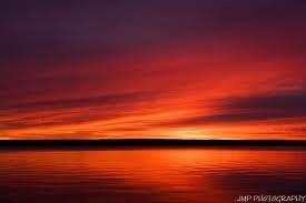
Sunset over Lake Gogebic
You can start this tour from either end of the lake. As you drive around the lake take the time to stop in at one of the restaurants for lunch or dinner as your view is over the lake. Lake Gogebic is the Upper Peninsula’s largest lake. 18 miles long and 3 miles wide, the driving distance around the lake is a little over 38 miles. Again take your time and enjoy the colors.
From Hwy 2 east of Marenisco take Hwy M64 north. After a few miles you will be on the south end of Lake Gogebic. About a mile further you will see hiking signs. This trail leads to a scenic overlook of the lake.
The west shore also features the parks. Gogebic County park is the furthest south, the State Park is in the middle and Ontonagon County park is on the north end. M64 will intersect with M28, go east this will take you into Bergland. Here you will find gas and supplies. About one mile east of Bergland is East Shore Road, turn right and follow the road until it comes to M64 on the south end of the lake. Turn left and you will return to Hwy 2
